Archives for Summer 2022

OUTLOOK NEWSLETTER ( Summer 2022 )

MAPPING THE UTILITY WORLD BELOW USING SUE

Subsurface Utility Exploration (SUE) is the process of vacuum excavation to expose underground utilities to determine their location, size, types, and depths to help avoid conflicts during construction.

Not far below the everyday places we walk and drive, exists a maze of utilities which carry critical components for our daily lives, carrying water, sewer, phone, and electricity to our homes and businesses. Navigating this unseen superhighway of conduits to avoid utility conflicts, delays, and service interruptions is a challenge that general contractors, utility providers, and municipalities face. Comprehensive and accurate mapping is critical for the success of their projects.

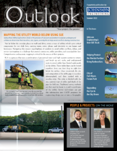
SUE is a process that uses a combination of pressurized water and high vacuum suction to remove and break up soil, rocks, and underground roots to reveal utility lines buried underneath all the debris. These utility lines can be buried anywhere from one foot deep to eight feet below the surface. Once uncovered, the size and composition of the utility pipe is recorded, photographed, and then marked with a wooden stake. The stake is labeled with the size, material type of utility and depth of the pipe for field use. Traditional survey methods are then used to locate x, y and z coordinates of the utility. Survey technicians can put this information into CADD programs for engineering design use or into a Geographic Information System (GIS) for a variety of mapping applications. After the dig is complete the hole or trench is then backfilled, and the soil is compacted back to its original condition.

Johnson Engineering began offering SUE services in the late 1990s and has continued to build upon our arsenal of resources. Our surveying and mapping team recently acquired the newest line of Vermeer’s high-capacity truck-mounted vacuum excavator. This 4-wheel drive diesel custom-built truck expands our service and efficiency. It has increased our ability to stay on site longer, with larger 2,200-gallon water supply and spoil tank capacity, as well as an increase to 3,000 psi water pressure to quickly break down compact dirt and debris. The vehicle also comes with a remote-controlled hydraulic telescoping boom to easily hold and extend the suction hose in place during excavation. The hydraulic cam-over rear door allows for storage as well as the ability to easily empty the spoil tank to restore the area to pre-existing conditions. This one-of-a-kind vehicle provides double the suction and lift power of traditional machines and is a cost-effective, efficient tool to utilize on your projects.

SUE is required by FDOT on all design projects that include underground infrastructure or earthwork excavation. Choosing the right company to quickly perform these underground investigations is vital to identify potential conflicts before they adversely affect the schedule and budget. Our team is specialty-trained, holding both state and federal certifications for quality levels A through D excavating and covering tasks, operation of heavy equipment and sign placement for gas companies. They are trained in traditional land surveying, as well as OSHA safety regulations, MOT regulations, Sunshine State One Call requirements and the other unique aspects of SUE technology. 

Having provided SUE throughout Southwest Florida for the last 20 years, we are continually searching for ways to provide our clients the most effective and efficient service. Comprehensive and accurate underground utility location and mapping of these vast and complicated networks has become a critical and essential asset to utility providers, general contractors, and municipalities alike and we have stepped up to the challenge of efficiently uncovering them. With the addition of our new SUE Vermeer system, we will continue to provide comprehensive and accurate underground utility mapping for our clients. 

For more information, contact the director of our surveying and mapping team, Matt Howard, PSM, at [email protected].

Read more

HELPING PROTECT THE FLORIDA PANTHER USING RADIOCOLLARS

For a few weeks this past February and March, the Florida Fish and Wildlife Conservation Commission (FWC) Panther Team conducted surveys on CREW Wildlife and Environmental Area in Naples to capture and radiocollar Florida panthers. Collaring panthers is a research tool that helps FWC to monitor and estimate population size, survival, assess health, and much more. Prior to joining Johnson Engineering in 2017, Dr. Jennifer Korn (“Jen”) was a panther biologist with FWC and was invited as a volunteer to assist on a few capture dates with the FWC Panther Team. 

On a very lucky day in February, the team captured the cat now known as FP263, an adult male panther estimated around 8 years old. Citizen scientist, Tom Mortenson, who has monitored the area with trail cameras for many years, first photographed this male panther in 2018. Tom named the cat “No Ears” because of his very small ears which are likely a result of past territorial fighting or infection. 

As with all captures, FP263 received a full veterinary assessment that included testing for feline leukemia (FeLV), giving vaccines, and collecting blood for genetics and further health testing. After the vet check, body measurements, and a GPS radiocollar, FP263 was released in the same area as capture. 

Jen was excited and thankful to be able to assist in this collaborative effort in panther recovery. If you have Florida panther questions or need assistance with a project pertaining to Florida panthers, wildlife crossings, trail camera monitoring, etc., do not hesitate to reach out to Jen at [email protected]. If you would like to read more about FWC and Florida panther monitoring and recovery, visit their website: https://myfwc.com/wildlifehabitats/wildlife/panther/.  

Read more

THE CITY OF FORT MYERS FORUM PARK

Johnson Engineering’s landscape architecture team, along with our civil engineers, recently completed the design and construction of the first of four planned phases for the City of Fort Myers’ Forum Park. The conceptual park design for this 23-acre park was prepared by Johnson Engineering in 2019 as part of the City’s master plan. 

This community park, located in The Forum neighborhood, just east of I-75 between SR-82 and Colonial Boulevard, will service a broader purpose than the traditional community park. This park will include not one, but four separate parks, each with unique features to serve the various demographics of the community. Based on the community needs assessment, the priorities of the area includes sports fields, fitness areas, recreational trails, playgrounds, pickleball courts, picnic areas, and special event locations. The parks will be connected to each other through recreation trails, unique landscaping, and open spaces.

The first park includes an outdoor fitness area which was made possible through a grant from the National Fitness Committee. Our team transformed a 2-acre piece of the park to include a covered outdoor fitness center, various shade structures, and pedestrian paths, as well as an emergency call box, a drinking water fountain, benches, and ample lighting, as well as Florida-friendly landscaping and irrigation.  

We completed the design, permitting, and bid documents in six months and Vantage Construction was able to bring the improvements into substantial completion within five months, which was no small feat considering the global challenges we have been experiencing. 

Our team enjoyed working with the City of Fort Myers on this project as it will bring the community together through outdoor recreation, parks, fitness, and nature. 

For more information, contact Jeff Nagle, RLA at [email protected]. 

Read more

UPGRADING OUR EYE IN THE SKY DRONE

 Johnson Engineering has recently upgraded our drone capabilities, adding a second drone to our arsenal, the new DJI Mavic 3. This compact, lightweight drone allows for a longer flight time, offers higher resolution camera/video capabilities, and doubles the distance we can fly from base. 

We currently have four in-house drone pilots, all with Federal Aviation Administration (FAA) 107-Certified Unmanned Aircraft Systems (UAS) pilot certification. Drones allow us to create cost-effective, high-quality drone-based aerial images and video, data for analysis, surveying, aerial mapping for a variety of applications in the engineering, environmental, construction, mining, and agricultural industries. We can assist with identifying problems and formulating solutions for your project using information provided by our drone footage.

If you’re interested in adding drone-based aerial or video production services to your existing project or have a new project that would benefit from drone-based aerial imagery or videos, please contact your Johnson Engineering project manager or our Marketing Director, Juli Kern, at [email protected] , to discuss how we can best serve your specific needs.

Read more